Polar Vortex: The Polar Vortex is once again making its presence known in the latest winter weather forecast. If you are living in North America or Europe, brace yourself. Early February could bring a dramatic shift in weather, and it all starts thousands of feet above the ground. A sudden temperature surge in the stratosphere is stirring things up, and that means the Polar Vortex might be on the move.
This article dives into what is happening up there, why it matters down here, and what kind of weather we can expect in the coming weeks. From disrupted vortex patterns to the threat of widespread Arctic outbreaks, we will cover every angle of this developing story. We will also unpack the science behind this winter phenomenon and what recent weather models are forecasting for your region.
What is the Polar Vortex and How Is It Changing This Winter?
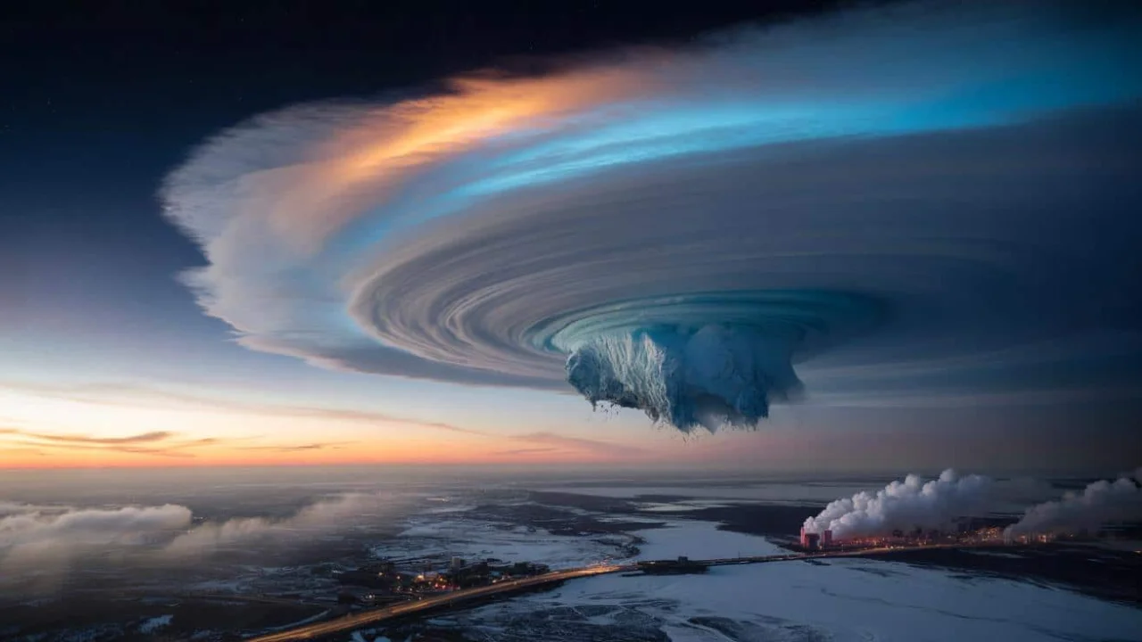
The Polar Vortex is a massive circulation of cold air that spins around the Arctic. When it is strong, it keeps frigid air locked in the polar regions. But when it weakens or splits, all that cold air escapes and heads south. This winter, forecasts are pointing to a major disruption of the vortex caused by a stratospheric warming event. This sudden change can shake up weather patterns across the globe, especially in the Northern Hemisphere.
What makes this shift so important is how it directly influences surface-level weather. When the vortex becomes unstable, it sets off a chain reaction in the atmosphere, pushing Arctic air into areas that usually stay milder. We are already seeing signs of this with an oval-shaped vortex stretching toward North America. And with early February approaching, the models suggest we might be in for one of the coldest spells of the season. Whether you are in Canada, the central United States, or northern Europe, these changes are worth watching closely.
Polar Vortex Shift Overview Table
| Key Area | Details |
| Current Condition | Disrupted and elongated shape |
| Trigger Event | Sudden rise in stratospheric temperatures |
| Affected Regions | United States, Canada, Northern and Central Europe |
| Timeline | Late January into early and mid-February |
| Main Risk | Extreme cold, heavy snow, increased storm activity |
| Forecast Models | ECMWF, GFS both confirm weakening of vortex |
| Upper Atmosphere Change | Stratospheric warming and high-pressure anomalies |
| Surface Level Effect | Cold Arctic air pushing into mid-latitudes |
| Storm Forecast | High winter storm severity over U.S. regions |
| Coldest Period Expected | First half of February |
Polar Vortex Core and Arctic Cold Advancing South
Right now, the core of the Polar Vortex is being pulled out of its usual tight spin around the North Pole. Thanks to strong high pressure forming in the stratosphere, the vortex is stretching, deforming, and pushing parts of its core into North America. What that means for you is more than just a chilly day. It could lead to widespread Arctic outbreaks bringing dangerous wind chills, icy conditions, and major winter storms.
Meteorologists are already tracking the pattern and see a corridor forming that allows cold air to dive into southern and eastern Canada, pushing down into most of the continental United States. Some areas, especially in the central and eastern U.S., are expected to face a strong blast of Arctic air. This is not just typical winter cold. We are talking about serious drops in temperature that may affect travel, infrastructure, and daily life.
Sudden Stratospheric Warming and Vortex Breakdown
A powerful phenomenon is behind the changing behavior of the Polar Vortex. Sudden Stratospheric Warming (SSW) is when temperatures in the stratosphere spike rapidly, causing pressure systems to rise and knock the vortex off balance. This type of event can fully split the vortex into two or more smaller vortices, each carrying Arctic air south into different parts of the globe.
Early February is when this shift is expected to peak. Forecasts show massive high-pressure zones forming over the polar region, and temperatures in the stratosphere could rise more than 50 degrees Celsius above normal. This warming is already visible in temperature anomaly charts, showing an aggressive disturbance that may lead to a full collapse of the vortex. When this happens, the impact trickles down through the layers of the atmosphere, finally reaching the surface with full force.
Forecast Maps Show Arctic Corridor Forming
Forecast models are painting a cold picture. Over the next few days, a direct Arctic corridor is forming, connecting central and eastern Canada with much of the U.S. The only areas expected to stay relatively untouched are the far southwest and parts of Florida. For the rest of the country, deep freezes, snow, and icy roads could become part of daily life again.
Europe is also in the crosshairs. While the southern part may enjoy mild conditions for now, northern and central Europe could see a shift as the effects of the stratospheric changes begin to show. For countries like the United Kingdom, Germany, and Scandinavia, colder air and unsettled weather may become the trend for February.
Winter Storm Outlook: What to Expect on the Ground
With the Polar Vortex destabilizing, storm activity is set to increase. The Winter Storm Severity Index shows high chances of intense winter conditions across the central and eastern U.S. for the first week of February. This includes heavy snow, freezing rain, and high-impact travel disruptions.
The risk is not just cold temperatures but how they interact with storm systems already forming. As the Arctic air settles in, it creates the perfect environment for large snowstorms, especially in regions that typically see mixed precipitation. Energy demands are also expected to rise as temperatures drop well below average.
Extended Forecast: February’s Cold Potential
Looking beyond the first week of February, long-range forecasts suggest the cold may not go away quickly. ECMWF models show that by mid-February, another cold wave could take over much of North America. Even though early February might begin with some milder temperatures in the northern U.S., those will likely be short-lived.
This trend aligns with previous events where a Polar Vortex collapse triggered cold air releases over several weeks. Across Europe, similar patterns are expected with colder air spilling from the north into western and central regions as the month progresses.
2 Key Impacts of Polar Vortex Disruption
1. Longer and Stronger Cold Waves
- Once the Polar Vortex breaks down, cold air spreads far beyond the Arctic. This can lead to prolonged freezing conditions that affect transportation, agriculture, and energy systems.
2. Increased Risk of Severe Winter Storms
- With cold air locked in place and moisture nearby, large snowstorms and ice events become more likely. Cities not used to extreme winter may experience serious disruptions.
FAQs
What exactly is the Polar Vortex?
The Polar Vortex is a large system of rotating cold air that circles the Arctic. When it is strong, it keeps that air contained. When it weakens, cold air can spread far south.
Why does the vortex break apart?
A sudden increase in temperature high above Earth, called Sudden Stratospheric Warming, puts stress on the vortex and can split it into smaller parts.
Is this unusual for winter?
Disruptions in the Polar Vortex happen every few years, but the strength of this year’s warming event makes it more impactful than usual.
Which areas will get the coldest?
The central and eastern United States, southern Canada, and parts of Europe like Scandinavia and Germany are expected to face the worst of the cold.
How long will the cold last?
Forecasts suggest the Arctic air could stick around through mid-February, especially after the main warming event in early February.