Netherlands land reclamation is one of the most fascinating success stories in climate resilience and modern engineering. While many countries are still reacting to rising seas with panic, the Dutch have been calmly redesigning their coastline. They have turned water into an ally rather than an enemy. Over the past decade, this country has managed to quietly reshape its coastal map and reclaim new land without major disruptions or headlines.
In fact, the Netherlands land reclamation approach has become a model for the world. It is a strategy rooted in science, patience, and long-term vision. By redirecting rivers, controlling sediment flow, and using natural forces, the Dutch have built up their coast while keeping ecosystems intact. This blog dives into how they did it, what it means for the future, and what other nations can learn from this quiet transformation.
Netherlands Land Reclamation: Working With Nature Instead of Fighting It
What sets the Netherlands land reclamation strategy apart is how subtle and sustainable it is. Instead of building massive concrete walls, Dutch engineers decided to guide water rather than block it. They altered the flow of rivers like the Rhine and Meuse through small but smart changes. These changes have reshaped the movement of sand and sediment, allowing new land to form naturally over time.
The Sand Motor project is a great example. This massive sand deposit near The Hague was designed to let waves and wind slowly carry sand along the coast. It looks like a normal beach but is actually one of the most advanced shoreline protection systems in the world. Other efforts involve reopening side channels and reshaping river mouths so that water spreads safely during floods instead of damaging urban areas. It is a shift in mindset from “How do we keep water out?” to “Where can water safely go?”
Key Overview of Netherlands Land Reclamation Efforts
| Key Element | Description |
| Coastline design | Planned and shaped using redirected rivers and sand distribution |
| Sand Motor project | A strategic sand deposit designed to nourish beaches naturally |
| River redirection | Modified flows of the Rhine and Meuse to influence sediment placement |
| Room for the River | Controlled flood zones allow water to spread safely inland |
| Long-term planning | Projects designed with 20 to 30-year visions, not short-term fixes |
| Reduced concrete usage | Nature-based solutions replace hard structures like sea walls |
| Coastal monitoring | Constant evaluation and data collection to improve performance |
| Floodplain restoration | Areas given back to rivers to reduce pressure downstream |
| Community integration | Farmers, fishers, and residents involved in planning and compromises |
| Land expansion | New land and dunes formed without traditional reclamation walls |
The coastline was designed, not discovered
The Dutch coastline is no accident. It is a living, evolving structure, shaped by decades of engineering, research, and nature-based solutions. What may seem like untouched dunes or beaches are often the result of carefully executed plans. On satellite maps, you can see how the shoreline has changed shape over the years. Soft curves have replaced harsh lines. New sandbars have emerged. River mouths have shifted.
Much of this is done behind the scenes. Before a single grain of sand is moved, Dutch engineers simulate the results using digital models and wave basins. The Sand Motor, for example, was not just dumped randomly. It was placed in a specific location where natural forces would spread it in a way that supports the entire coastline. These kinds of quiet interventions have helped the Netherlands reclaim more land and keep existing land safe from erosion.
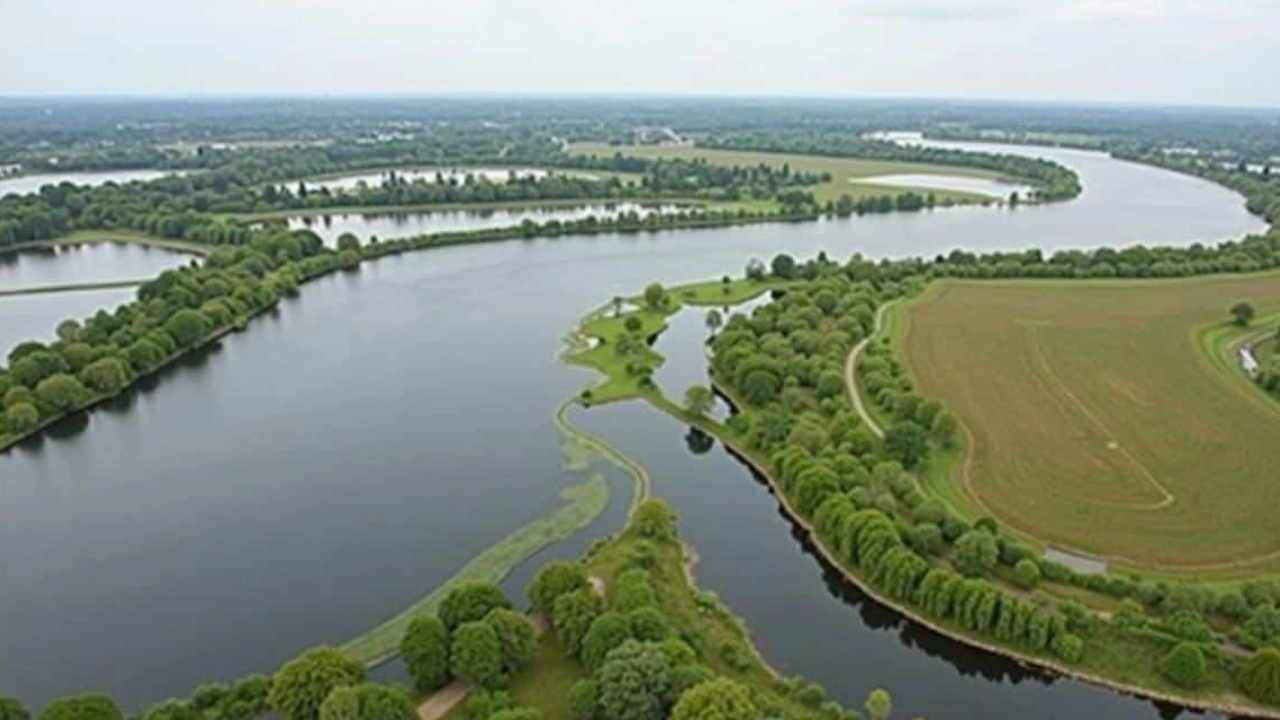
Rivers, currents, and sediment: The hidden tools
Rivers carry more than just water. They bring silt, sand, and tiny stones from across Europe to the coast. This sediment is a key part of the Netherlands land reclamation method. By guiding how and where rivers meet the ocean, Dutch engineers can control where sediment settles. Over time, this creates new dunes and even usable land.
These projects are not overnight miracles. They require steady work, monitored progress, and careful timing. Adjusting one inlet or opening a new side channel may seem minor, but over seasons and years, it shifts entire patterns of erosion and deposit. The idea is not to fight nature’s energy but to direct it. That is what makes the Dutch strategy so powerful and sustainable. It avoids the damages of hard barriers and gives the sea space to move without harm.
Two key innovations in Dutch coastal management
- The Sand Motor
This man-made sand peninsula near The Hague helps protect the coast by using natural forces to move and distribute sand over several kilometers. It reduces the need for frequent human intervention and strengthens beaches over time. - Room for the River
Instead of forcing rivers into narrow channels, this program allows them to flood certain low-lying areas safely. It reduces pressure on dikes, lowers flood risks in cities, and restores wetlands that support wildlife.
How to move rivers without declaring war on nature
What is truly remarkable is that the Dutch did not move rivers by building huge dams or walls. They did it by making small, strategic changes. Lowering certain riverbanks, creating new outlets, or opening former floodplains allows rivers to spread naturally during heavy rainfall. These changes redirect the flow of water, which also shifts how sediment travels.
This means some places that used to lose land to the sea are now gaining it. Shoals and sandbanks grow where erosion once dominated. New dunes form that act as soft buffers. The best part is that these natural defenses often require less maintenance than concrete barriers. They adapt to changing water levels and can evolve with the climate.
What a redrawn coastline means for the rest of us
Standing on reclaimed land in the Netherlands feels oddly normal. Children ride bikes on roads that sit below sea level. Towns thrive in areas that used to be part of the sea. What is visible is not a fortress but a flexible, living border with water. That is the heart of Netherlands land reclamation.
The lesson here is that coastlines do not need to be fixed lines. They can be shaped, negotiated, and even expanded. The Dutch model is not just about keeping water out but learning how to live with it. For countries facing rising sea levels and frequent flooding, this method offers hope. It requires planning, patience, and teamwork across sectors, but it works. And in a changing world, that kind of adaptability may be the best defense we have.
FAQs
1. How has the Netherlands reclaimed land in recent years?
The Netherlands used river redirection, sediment management, and natural sand movement instead of building new sea walls. These efforts have quietly expanded the coastline.
2. What is the Sand Motor and how does it work?
The Sand Motor is a large sand deposit placed near The Hague. It uses wind and waves to naturally distribute sand along the coast, strengthening beaches over time.
3. Can other countries follow the Netherlands land reclamation model?
Yes, but it depends on local geography. While the full model may not apply everywhere, many countries can use similar strategies like controlled flooding and sediment use.
4. Is this method environmentally friendly?
Compared to traditional hard engineering, yes. It restores natural habitats, supports biodiversity, and reduces harm to river and sea life.
5. How long does land reclamation take using this approach?
It takes years, often decades. But because the changes are natural and steady, the results tend to be more sustainable and adaptable over time.