Africa splitting in two might sound dramatic, but it is not science fiction. It is real, and it is happening slowly, right beneath our feet. Geologists have confirmed that East Africa is gradually tearing itself away from the rest of the continent. This is not some distant theory. There is physical proof in the form of massive cracks in the ground, deep valleys, and active volcanoes.
In fact, scientists believe the process of Africa splitting in two could lead to the birth of a brand-new ocean. Over millions of years, what we now know as the East African Rift will continue to expand, eventually flooding with seawater and forming a sea between two landmasses. In this blog, we will explore how this split began, what causes it, what it could mean for future generations, and why scientists are keeping such a close watch.
Africa Splitting in Two: What You Should Know
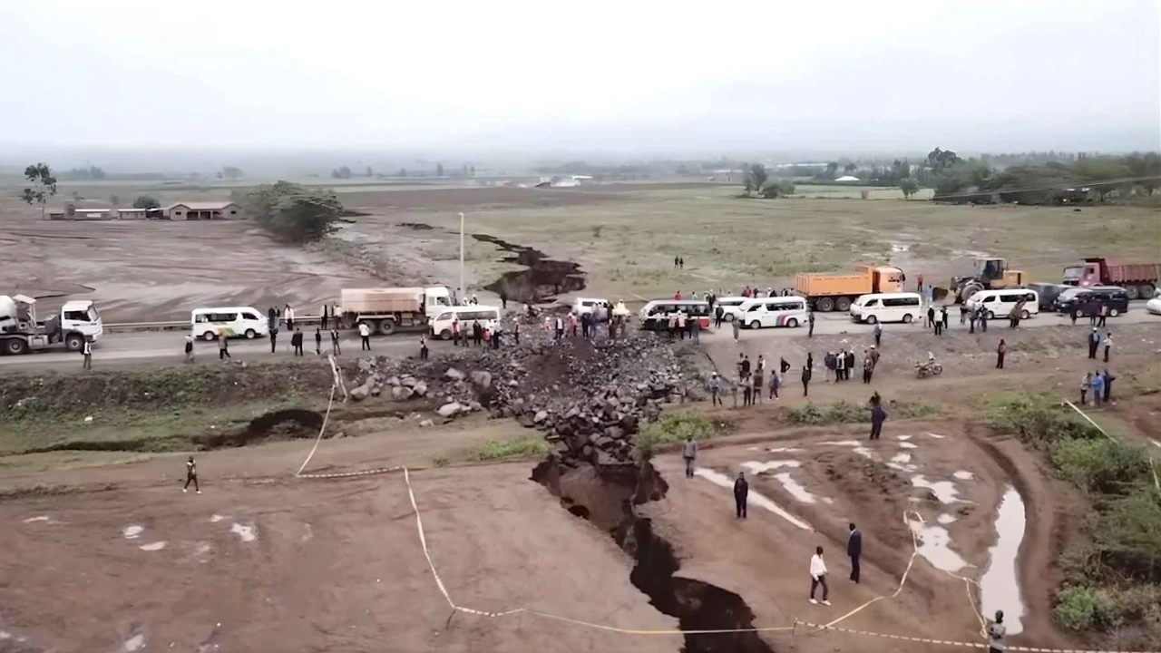
The phrase Africa splitting in two refers to a very slow geological process where the eastern portion of the continent is being pulled apart from the main landmass. This is happening along the East African Rift, which stretches from the Red Sea down to Mozambique. Two tectonic plates, the Nubian Plate and the Somali Plate, are slowly moving in opposite directions. This movement is tearing the land, creating deep cracks and valleys, and even triggering volcanic eruptions.
While this process will take millions of years to complete, scientists already see clear evidence. In Ethiopia and Kenya, large fissures in the ground have appeared. These are not just surface cracks. They are signs of massive movements deep beneath the Earth’s crust. If the rift continues to widen, seawater from nearby oceans could flood in, eventually forming a brand-new ocean that separates East Africa from the rest of the continent.
Overview Table: Africa Splitting in Two
| Key Aspect | Description |
| Main Process | Tectonic plates slowly pulling apart |
| Geological Zone | East African Rift |
| Plates Involved | Nubian Plate and Somali Plate |
| First Signs Detected | Around 25 to 30 million years ago |
| Visible Evidence | Cracks, valleys, volcanic eruptions, land sinking |
| Current Speed of Movement | Few millimeters per year |
| Potential Result | New ocean between East and Central Africa |
| Countries Affected | Ethiopia, Kenya, Tanzania, Mozambique, others |
| Risks Involved | Earthquakes, volcanic eruptions, displacement of communities |
| Long-Term Impact | Changes to geography, climate, ecosystems, and economic development |
The East African Rift: A Slow Geological Transformation
The East African Rift is one of the most geologically active regions on Earth. It runs through several countries and acts as a dividing line between two massive tectonic plates. This rift is not a single crack but a complex system of fault lines. Over time, this region has experienced volcanic eruptions, ground collapses, and the formation of deep valleys. These are all signs that the Earth’s crust is under stress.
In some areas, land is rising while in others, it is sinking. This constant movement is why scientists believe the rift will eventually split the continent. As the rift deepens, new lakes and rivers are also forming. All of these changes hint at what lies ahead—a massive shift in the shape of the African continent.
What’s Causing the Split?
The Earth’s outer shell is divided into large plates that float on molten rock. These plates are always moving, though the motion is incredibly slow. In East Africa, the Nubian Plate is moving away from the Somali Plate. This movement is what causes the land to stretch and crack.
Heat and pressure from below the surface contribute to this process. As the plates continue to drift apart, the crust becomes thinner and eventually breaks open. Over time, this leads to more surface cracks, valleys, and even volcanic eruptions. While this may not affect daily life right now, it is shaping the future of the entire continent.
How Did the Rift Begin?
Geologists believe the East African Rift began forming around 25 to 30 million years ago. Back then, the plates started to pull apart, creating minor cracks and valleys. With time, these small fractures grew larger, and volcanic activity began reshaping the region. Lava flowed through the cracks, forming new landforms and increasing the size of the rift.
What makes this even more fascinating is that the rift is still growing. New cracks are being discovered, and older ones are widening. It is a continuous and natural part of how the Earth evolves. Each eruption, earthquake, or ground shift adds another layer to the story of Africa splitting in two.
A New Ocean on the Horizon?
One of the most exciting possibilities of Africa splitting in two is the birth of a new ocean. If the rift keeps widening and the land continues to sink, it is only a matter of time before seawater fills the gap. This will start as a narrow sea and eventually become a vast body of water, similar to the Red Sea or even larger.
This change will not only redefine Africa’s borders but also reshape global geography. Countries that were once landlocked might gain coastlines. New islands could form, and trade routes may shift. Although this transformation is still millions of years away, the process has already begun.
Potential Impacts on Africa’s Future
• New Coastlines and Ecosystems
As Africa splitting in two continues, it will create new coastlines. Countries like Ethiopia could find themselves with access to the ocean. This would open up new opportunities for trade, fishing, and travel. However, it will also disrupt existing ecosystems. Plants and animals that depend on land-based habitats may struggle to survive or migrate elsewhere.
• Changes to Climate and Environment
An ocean forming in East Africa would change the local climate. Oceans influence temperature, rainfall, and wind patterns. Some regions might get more rain, while others become drier. These shifts would impact agriculture, water supply, and daily life. It is a reminder that geological changes have far-reaching effects beyond just geography.
Impact on Human Populations
The gradual process of Africa splitting in two could lead to the displacement of communities in the future. Areas near active faults or volcanoes may become unsafe. Rising sea levels could flood low-lying regions. On the flip side, new ports and coastal cities might rise, boosting economies.
Governments and city planners will need to think long-term. They may have to invest in stronger infrastructure, monitor geological activity, and plan for population shifts. Education and awareness will be key to helping people understand and adapt to the coming changes.
The Role of Scientists in Understanding the Rift
Scientists are using satellite data, GPS systems, and field surveys to monitor the East African Rift. These tools allow them to track the movement of tectonic plates and detect changes in the land. By studying this region, researchers gain valuable insight into how continents break apart and how new oceans are formed.
This knowledge helps predict earthquakes and volcanic activity, making it easier to prepare for disasters. It also adds to our understanding of Earth’s natural processes. Every new crack or shift in the ground tells us more about the incredible journey of Africa splitting in two.
FAQs
What does Africa splitting in two mean?
It refers to the slow process where East Africa is moving away from the rest of the continent due to tectonic plate movement.
Is a new ocean really forming in Africa?
Yes, scientists believe that over millions of years, the rift will widen enough for seawater to fill the gap, creating a new ocean.
Is this dangerous for people living nearby?
While the process is slow, areas near fault lines may experience earthquakes or volcanic eruptions that can affect local communities.
How do scientists know this is happening?
They use tools like GPS, satellite images, and field studies to track the movements of tectonic plates and monitor changes in the Earth’s surface.